- Business
- Esoteric
- Fitness & Gym
- Health
- Hypnosis
- Management
- Marketing & Selling
- Massage – SPA
- Parenting
- PUA Seduction
- Science
- Self Improvement
- Art
- Investing
- Painting & Sculpting
- Tai Chi & Martial Arts
- Qigong
- Taoism
- Design & Graphics
- Medicine
- Exams
- Spirituality & Religion
- Hobbies & Fixing & Woodworking
- Photography & Film Making
- Networking & Lan
- Forex & Trading
- IQ & Memory
- Vision & Eye Care
- Swimming & Scuba diving & Water Sports
- Security & Hacking
- Travel
- Cooking
- Driving & Flighting
- Languages
- Computers & Programming
- Building & Home Improvement
- Music
- Astronomy
- History
- Mathematics
- Philosophy
- Literature & Writing
- Economics & Finance
- Sewing
- Hunting
- Electronics
- Psychology & Psychiatry
-75%


Sexual Energy Transmutation: the secret path to Health, Wealth and Genius
Original price was: $20.00.$5.00Current price is: $5.00.
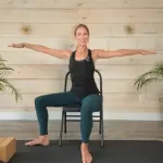
Strength & Stability Chair Yoga Course
Original price was: $20.00.$5.00Current price is: $5.00.
Solar Panel Farm Site Selection Using Remote Sensing and GEE
Original price was: $20.00.$5.00Current price is: $5.00.
Description
Published 8/2025
MP4 | Video: h264, 1280×720 | Audio: AAC, 44.1 KHz, 2 Ch
Language: English | Duration: 55m | Size: 511 MB
Solar Farm Site Selection Using Solar Radiation, Land Cover, DEM, and Google Earth Engine
What you’ll learn
Understand the fundamentals of remote sensing data and its application in environmental analysis.
Learn how to process and analyze satellite data such as DEM, landcover, and solar radiation using Google Earth Engine.
Develop skills to identify and map suitable sites for solar panel farms by integrating multiple geospatial datasets.
Gain hands-on experience in creating suitability models and exporting geospatial results for real-world renewable energy planning projects.
Requirements
No prior experience with Google Earth Engine is required — the course will guide you step-by-step.
Description
The growing demand for renewable energy sources has made solar power a critical component of sustainable development. This course offers a comprehensive introduction to using remote sensing and Google Earth Engine (GEE) for solar farm site selection. It begins with foundational concepts of remote sensing, helping learners understand different types of satellite data and their applications in environmental analysis.Next, the course covers site suitability mapping principles, focusing on how to analyze various environmental factors such as elevation, slope, land cover, and solar radiation to assess land suitability. Students will gain practical experience working with multi-source data in GEE, a cloud-based geospatial platform that enables efficient processing and visualization of large datasets.The course culminates with an implementation project where learners create a solar farm suitability map for a chosen area using real-world satellite data. They will learn to apply masks for unsuitable land covers, calculate solar radiation indices, and integrate multiple layers into a weighted suitability model.By the end, students will have the skills to perform advanced geospatial analyses, automate workflows in GEE, and make data-driven decisions for solar farm planning. This course is perfect for those aiming to contribute to renewable energy projects, environmental monitoring, or spatial data science using cutting-edge tools.
Who this course is for
Students, researchers and professionals in agriculture, environmental science, geography, or remote sensing looking to apply satellite data in real-world scenarios.
Homepage
https://www.udemy.com/course/solar-panel-farm-site-selection-using-remote-sensing-and-gee/
Shipping & Delivery
DIGITAL DELIVERY ONLY
This is digital product THE DOWNLOAD LINK SEND 12-24 HOURS AFTER UPON PURSUASE AND PAYMENT CLEARS"
- The digital files are uploaded on PCLOUD
- 12-24 hours delivery time
- the download links expire after 7 days and need to download them
- to renew the download link after expiration have one additional fee $5 per product
REQUESTS
Also we accept requests and course exchanges
In Course exchanges we are sending credits only
The credits will be the same price as we can sell course
"REFUNDS & RETURNS"
No Refunds on digital product
ONLY EXCHANGE
- Because of the abuse of the refunds from many customers i don't accept refunds
- We accept only 1 time exchange with product of the same price
- if you done mistake on the exchangeable product i don't recognize it as your mistake
- Exchanges only 3 days after the payment of your digital product. (if abused again i will do it 1 day)


